If you are studying geophysics, applied mathematics, physics, or computer science, you have likely encountered wave equations and optimisation problems. At Viridien, we translate these theoretical concepts into commercial reality with Full Waveform Inversion (FWI).
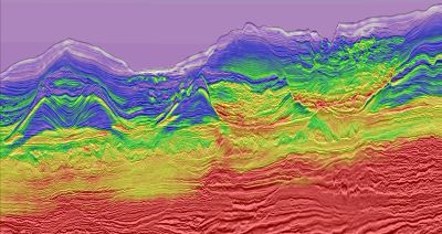
Viridien utilises FWI as a core technology to image the earth's subsurface with unprecedented accuracy. Traditional seismic imaging techniques, such as conventional reflection tomography, are limited because they use only the travel-time kinematics of primary seismic waves - the first reflection from each geological interface. FWI makes use of the entire wavefield, extracting vital information from both amplitude and phase, as well as other seismic arrivals like diving waves and multiple reflections.
Here is how our teams apply FWI in practice, and where Viridien has pushed beyond standard industry implementations:
- Iterative Optimisation: FWI is a massive, iterative problem-solving loop. We start with an initial earth model and generate synthetic data through forward modelling via the wave equation. We then compare this synthetic data against actual recorded seismic data. The algorithm iteratively updates the earth model until the difference between our synthetic data and the real data is minimized.
- Avoiding Local Minima: To maximize computational efficiency and avoid converging on local minima (cycle skipping), it is common practice to perform the update in a series of frequency steps, starting with the lowest usable frequencies. Because cycle skipping remains a major challenge even with frequency stepping, Viridien developed Time-Lag FWI. This introduces a time-lag cost function into the modelling process, allowing the algorithm to converge accurately even in demanding geological scenarios with sub-optimal data.
- Overcoming Real-World Distortion: The earth is not a textbook environment. Underground gas, for example, causes frequency-dependent dissipation, distorting the wave's phase and attenuating its amplitude. Viridien’s advanced FWI implementation compensates for these spatial variations to reveal the complex geology hidden beneath.
- Incorporating Elastic Physics: Standard approaches often rely purely on acoustic (compressional P-wave) data. Viridien’s Elastic FWI incorporates the physics of elastic wave propagation, utilizing both P-waves and shear (S-waves). This multi-parameter approach honors the true elastic nature of the earth, providing higher fidelity models where large acoustic impedance contrasts occur, such as salt-sediment boundaries.
The Result: Viridien's advanced FWI technology turns raw data into high-definition velocity and rock property models. These are used directly for imaging complex geological structures, identifying potential geo-hazards, and conducting time-lapse monitoring of reservoirs containing oil and gas or injected carbon dioxide.