MSc in Astronomy, University of Sussex; BA in Natural Sciences, University of Cambridge.
Current project: North Rona Ridge 3D, a rich azimuth seismic survey. The 3600 km² project focuses on delivering high-resolution seismic data in a prospective but underexplored area north-west of the Shetland Isles.
Current focus: Removing multiple reflections of the seabed recorded in the data for the case where the initial primary reflection from the seabed is post-critical.
Before specialising in physics and astronomy, I studied a range of topics in my first degree including earth sciences; there was something about the study of our planet and what goes on beneath our feet that always interested me, so I knew I wanted to return to that field after university.
Geophysics and seismic imaging is perfect for me: combining my knowledge of physics and excitement for geology. I was fairly rusty on my geophysics knowledge when I started, but the great training at CGG builds from the ground up and assumes no prior knowledge of geophysics so I found it easy to refresh old concepts and learn new ones.
I have really enjoyed my time at CGG since I joined in 2018 both in terms of the work itself and the friendly working environment. Crawley is also a great place to live with easy rail links to London and Brighton as well as Gatwick airport nearby.
The current project my team is working on is the North Rona Ridge 3D, a rich azimuth seismic survey. The 3600 km² project focuses on delivering high-resolution seismic data in a prospective but underexplored area north-west of the Shetland Isles. It is a multi-client (MCNV) survey which is a business model where CGG owns the data and licenses it out to clients.
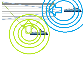
It means seismic waves are sent into the earth from different directions by different source vessels and recorded using a single receiver array towed by one of the vessels.
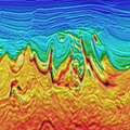
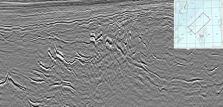
This is necessary because complex geology and highly refractive layers can cause ray bending that can leave portions of the subsurface poorly illuminated by seismic waves arriving at just one angle. The seismic image shows the high impedance volcanic intrusions (the bright steeply dipping events) which characterise this area and are notorious for causing ray bending and scattering.
What is particularly innovative about this survey is that both vessels are operating triple sources using simultaneous source technology as opposed to the conventional dual source flip-flop approach where one source fires and then the next source fires at constant time intervals. This improves the spatial resolution and efficiency of the survey although requires advanced deblending algorithms to separate out the waves emitted from the sources which overlap each other.
My current focus on the project is Model-based Water-layer Demultiple (MWD), a technique designed to remove multiple reflections of the seabed specifically where it gets very shallow.
These can be very challenging to attenuate because where the water depth is less than half the distance between the seismic source and the nearest receiver, the water bottom reflection is recorded beyond the critical angle of reflection. This provides a poor basis for conventional predictive techniques so to bypass this limitation MWD models the Green’s function of the waterbottom primary reflection instead.